In the state of Uttarakhand, the ground water level is continuously declining due to the increasing use of ground water and its unplanned exploitation and lack of adequate recharge. Out of the 13 districts of the state, most of the land area of 11 districts is mountainous. There too, plans for drinking water and irrigation etc. are being made continuously on rivers, streams and sources and due to lack of any plan for recharging the sources, a decrease in the flow of sources is being seen and some sources are reported to be drying up. In view of the increasing possibilities of industrialization in the state, there is a possibility of ground water getting polluted in the future. Despite the abundance of water here, there has always been a shortage of water for drinking water and irrigation etc. To overcome the fall in the level of ground water and the decrease in the flow of rivers, streams and sources of mountainous districts, it is necessary to control pollution, and planned use of water for drinking water, irrigation and industry etc.
Before the formation of Uttarakhand state, a separate “Ground Water Department” existed in the erstwhile state of Uttar Pradesh. The underground water requirements of the plain areas of Uttaranchal state were met by this department. For this, many ground water measuring instruments/sites and rain water measuring instruments/sites are established in the plain areas, from which data is collected and used. After the formation of Uttaranchal state, there was no institution/department left for this work and Uttar Pradesh has also abandoned the work related to ground water in the Uttaranchal region, due to which data related to underground water is not available at present. Anyway, the sites established by Uttar Pradesh were not sufficient for good data, for which additional stations would need to be set up and employees would need to be employed. There was no arrangement in the past to collect data from the mainly hilly areas of Uttaranchal where the flow of rivers, streams and sources is continuously decreasing. The time has come to find out the reasons for the loss of water flow in those areas. Sources should be identified at various places and their flow should be measured and conclusions should be drawn by comparative study. The public was well aware of artificially stopping water with trees and bushes on rivers and streams and preserving canals. At present, this trend is coming to an end. Canals and streams are getting destroyed. There was no system left to stop the flow of rivers and streams at various places and stop it. In such a situation, it is necessary that first of all data should be collected and construction should be done as per the design. In the present scenario, the idea of a ground water department without remote sensing and GIS technology is meaningless in terms of correct and complete assessment of ground water, complete information about land use, assessment of irrigated/non-irrigated land, selection of ideal project site. The following works will have to be done with a view to doing the complete work of ground water and implementing the projects.
In the state of Uttarakhand, the ground water level is continuously declining due to the increasing use of ground water and its unplanned exploitation and lack of adequate storage (recharge). Out of the 13 districts of the state, most of the land area of 11 districts is mountainous. There too, plans for drinking water and irrigation etc. are being made continuously on rivers, streams and sources and due to the absence of any plan for recharging the sources, a decrease in the flow of the sources is being seen and some sources are reported to be drying up. In view of the increasing possibilities of industrialization in the state, there is also a possibility of ground water getting polluted in the future. Despite the abundance of water here, there has always been a shortage of water for drinking water and irrigation etc. To overcome the fall in the level of ground water and the decrease in the flow of rivers, streams and sources of mountainous districts, it is necessary to control pollution, and planned use of water for drinking water, irrigation and industry etc.
Before the formation of Uttarakhand state, a separate “Ground Water Department” existed in the erstwhile state of Uttar Pradesh. The underground water requirements of the plain areas of Uttaranchal state were met by this department. For this, many ground water measuring instruments/sites and rain water measuring instruments/sites are established in the plain areas, from which data is collected and used. After the formation of Uttaranchal state, there was no institution/department left for this work and Uttar Pradesh has also abandoned the work related to ground water in the Uttaranchal region, due to which data related to underground water is not available at present. Anyway, the sites established by Uttar Pradesh did not provide good data, for which additional stations will need to be set up and employees will be employed.
Earlier also there was no arrangement for collecting data of mainly hilly areas of Uttaranchal where the flow of rivers, streams and sources is continuously decreasing. The time has come to find out the reasons for the depletion of water reserves of these areas. Sources should be marked at various places and their flow should be measured and conclusions should be drawn through comparative studies. The public should be informed about artificially stopping water by using trees and bushes on rivers and streams and creating canals.
There was a lot of water in the ground. At present, this trend is coming to an end. The canals and streams are getting destroyed. There was no system of stopping the flow of rivers and streams at various places and recharging them. In such a situation, it is necessary that first of all, data should be collected and construction should be done according to the design. In the present situation, in order to make a correct and complete assessment of underground water, to gather all the information about land use, to assess irrigated/unirrigated land, to select the ideal project site, it is expected that the ground water department should be conceived without small scale and large scale technology. Work will have to be done with a view to carrying out the entire work of ground water and implementation of recharge schemes.
About 54 percent of the country is suffering from excessive water shortage, due to excessive exploitation of ground water in the plain districts of the state, the ground water level is continuously falling. According to the report of the Central Ground Water Board, Dehradun office, the water level is falling due to excessive exploitation of water in the plain areas of the state. According to the report, 5 development blocks of Haridwar, Nainital and Udham Singh Nagar districts are in extreme block status, while the situation is not satisfactory in some other development blocks as well. Due to continuous environmental reasons, there is a shortage of water for drinking and irrigation in some hilly areas during the summer season.
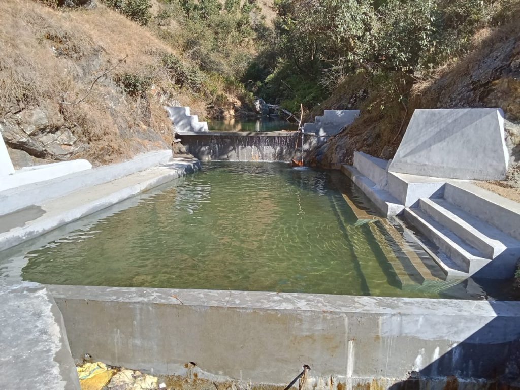
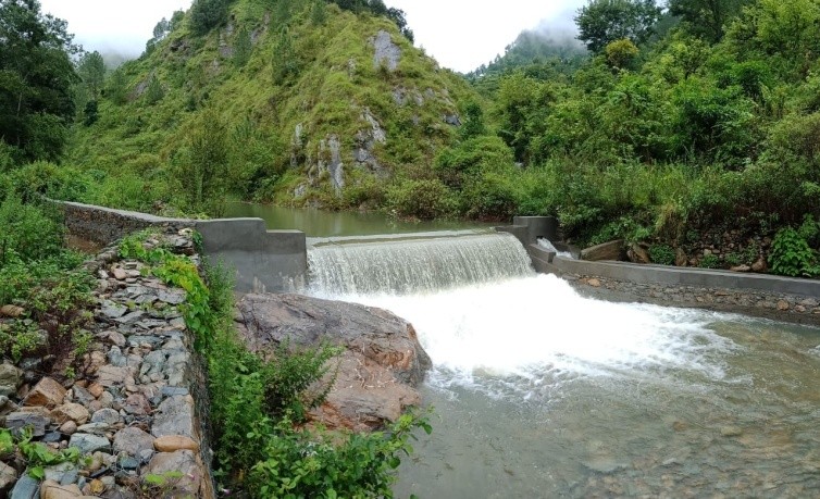
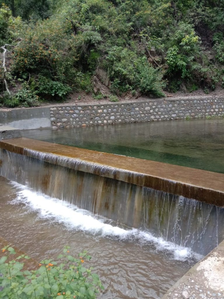
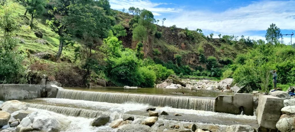
Along with irrigation, the Minor Irrigation Department is also working on water conservation and enhancement. For water conservation and enhancement, the department is constructing minor schemes –
1. Check Dam
The department is constructing check dams in hilly areas. While check dams work as permanent heads of irrigation schemes, due to which irrigation schemes remain continuously active, these schemes also conserve and enhance water.
Benefits of check dam construction:
- The head of irrigation schemes gets stability and remains functional throughout the year.
- It helps in preventing soil erosion and bed erosion.
- It works for water conservation and enrichment and water remains regularly filled in the upper part of the check dam.
- Due to increased moisture content in the areas around the check dam, the possibility of damage caused by vegetation is reduced due to greenery even in summer season.
- Apart from irrigation, the water collected from the check dam can also be used for various purposes such as fish farming, drinking water for animals, tourism, stabilizing the upstream ghat and other uses.
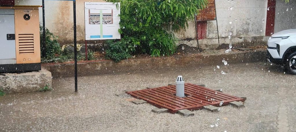
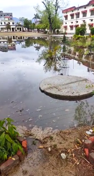
2. Recharge Shaft
Recharge shaft is an effective means of groundwater storage, in which rainwater runoff is artificially poured directly into the aquifer (groundwater storage area), which leads to an increase in the groundwater level. In view of the falling level of groundwater, there is an urgent need to work in this direction. Keeping this problem in mind, the department is doing the work of groundwater recharge through recharge shaft construction in the plain areas. Due to this, improvement in groundwater level is being seen in the areas where recharge shafts have been built.
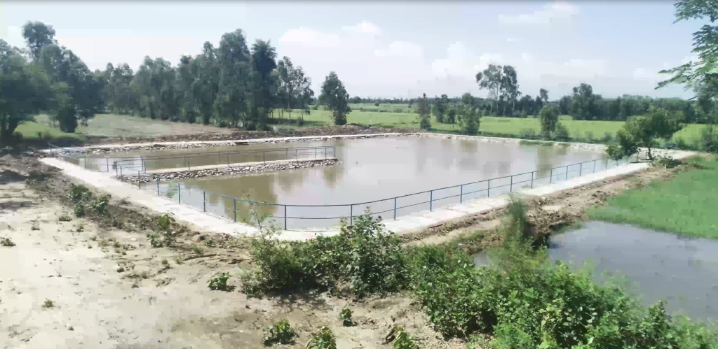
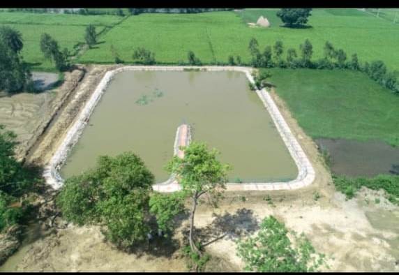
Pond construction:
Due to the neglect of ponds, today there is a shortage of water resources and a decline in groundwater level, which is adversely affecting the environment. Pond is not only a means of water conservation, but it is an important asset for the environment, economy, and society. Construction and conservation of ponds can play a big role in the sustainable development of the area.
Benefits:-
- Pond water is useful for irrigating fields, which helps farmers in irrigation, and reduces the cost of irrigation.
- Ponds provide ideal places for fish farming, which can become a source of employment for local people.
- Pearl farming can be done in ponds, which is a lucrative source of income for farmers and entrepreneurs.
- Beautiful ponds can attract tourists, which benefits the local economy.